


The Apara-Makiri-Punti Indigenous Protected Area (IPA) was dedicated in 2011, and covers 1.1 million hectares of South Australia’s arid Anangu Pitjantjatjara Yankunytjatjara Lands. Most of the IPA is made up of sandplain and dune country with a scattering of hills and rocky outcrops. The Musgrave Ranges are a striking feature in the north of the IPA.
Anangu manage their country according to Tjukurpa, traditional law, as they have for many thousands of years. Anangu say that as their ancestors travelled, they made changes to the landscape, leaving features that recorded their adventures and which testify to the traditional laws which were established at that time. These lines of features along the paths taken by the ancestors are sometimes known as songlines. The tjala, honey ant and the kalaya, emu, are two important Tjukurpa songlines that pass through Apara-Makiri-Punti, defining who owns and is responsible for managing this country.
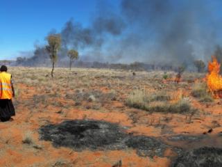
The Anangu Land Management Rangers undertake many different land management activities across the IPA. Regular cleaning of rockholes is important, as they were crucial for Anangu survival in these arid areas and today provide kapi, water, for birds and native animals. Patch burning is undertaken across the IPA to create a mosaic of vegetation of different ages which helps to increase local biodiversity. It can also minimise the effects of wildfires across the IPA and is an important part of Anangu culture.